
![MirzApur Full Movie Collection: ‘Mirzapur The Movie’ box office collection Day 11 [LIVE]: Pankaj Tripathi, Ali Fazal and Ravi Kishan film moves closer to Rs 200 crore domestic milestone on second Monday | Hindi Movie News](https://bekhabarnewss.in/wp-content/uploads/2026/09/mirzapur-the-movie-day-11-box-office-collection-live-image-credits-imdb-150x150.jpg "MirzApur Full Movie Collection: ‘Mirzapur The Movie’ box office collection Day 11 [LIVE]: Pankaj Tripathi, Ali Fazal and Ravi Kishan film moves closer to Rs 200 crore domestic milestone on second Monday | Hindi Movie News")







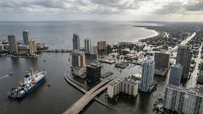
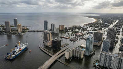
Life along the American coastline has always involved living with changing tides, storms and shifting shorelines. What is beginning to concern planners far more is the steady background rise in sea level that quietly increases the impact of every flood event. Nasa analysis reveals that using decades of satellite observations suggests the pace of that rise is unlikely to ease in the coming years. Instead, many parts of the contiguous United States could be dealing with water levels around a foot higher than they are now by the middle of the century. The increase will not be identical everywhere, but communities along the Gulf Coast and much of the southeast appear set to experience the largest changes, adding fresh pressure to places already vulnerable to regular flooding.
Nasa satellite data points to higher sea level rise by 2050
The assessment draws on almost three decades of satellite measurements that have tracked changes in the height of the world’s oceans. Those space-based observations were examined alongside long-running tide gauge records collected at coastal locations, with some of those records stretching back more than a century.The findings suggest that earlier estimates leaning towards the upper end of projected sea level rise are becoming increasingly consistent with what has actually been observed. For much of the contiguous United States, average sea level could stand as much as 12 inches, or roughly 30 centimetres, above current levels by 2050.
Which US coastlines could see the biggest sea level rise by 2050
| Region / Coast | Example city mentioned | Estimated sea level rise by 2050 | Key takeaway |
| East Coast | Norfolk, Virginia | 10–14 inches (25–35 cm) | Coastal flooding is expected to become more frequent as sea levels continue to rise. |
| Gulf Coast | — | 14–18 inches (35–45 cm) | Forecast to experience the largest average increase among U.S. coastlines. |
| Southeast US | — | Around 12 inches (30 cm) on average, with some locations expected to see higher rises | Satellite observations indicate faster rates of sea level rise than along the Northeast or West Coast. |
| West Coast | — | 4–8 inches (10–20 cm) | Lower projected increases, though rising seas are still expected to affect coastal communities. |
Sea level rise will vary sharply across US coastlines
The projected rise is far from uniform. Geography, local land movement and regional climate patterns all influence how much individual coastlines are expected to change. Previous federal projections indicate that the East Coast could see an average increase of around 10 to 14 inches by 2050. Along the Gulf Coast, estimates are higher, reaching between 14 and 18 inches. The western coastline is expected to experience smaller increases, generally between four and eight inches over the same period.Scientists say the southeast and Gulf regions continue to show faster rates of sea level rise than the northeast or Pacific coast. Predicting exact figures there remains more difficult because the landscape itself is changing in places. Some coastal areas are naturally sinking, while storms and longer-term climate patterns also influence year-to-year measurements.
How rising seas will worsen flooding
Sea level does not need to rise dramatically before coastal flooding becomes much more common. Even modest increases mean that high tides begin from a higher starting point, allowing water to reach roads, homes and infrastructure more often than before.Natural cycles add another layer of complexity. During the mid-2030s, a long-recognised wobble in the Moon’s orbit will temporarily increase the frequency and severity of high-tide flooding around US coastlines. This cycle occurs roughly every 18.6 years, but its effects will coincide with higher baseline sea levels than in previous decades. That combination is expected to produce more frequent nuisance flooding as well as increase the likelihood of more disruptive flood events during unusually high tides.
How Nasa and its global partners monitor Earth’s rising oceans
Monitoring sea level from space began in the early 1990s through an international partnership between Nasa and the French space agency CNES. Since then, successive missions have maintained an uninterrupted record of ocean height measurements, creating one of the most valuable long-term climate datasets available.The satellite in that sequence, Sentinel-6 Michael Freilich, launched in 2020 and continues collecting highly accurate measurements of sea surface height across nearly the entire globe. The mission is supported by several international partners, including Nasa, NOAA, the European Space Agency, the European Organisation for the Exploitation of Meteorological Satellites and CNES.