








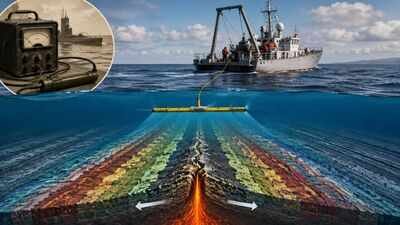
A device built to track enemy submarines during the Second World War went on to become one of the most important tools in Earth science. The fluxgate magnetometer, first developed to detect small disturbances in the planet’s magnetic field caused by metal hulls beneath the ocean surface, was later adapted by scientists to study the seafloor itself. According to Science News, the device’s origins trace back to 1936, when researchers designed a highly sensitive magnetic sensor, which was then made portable for aerial use during the war under the guidance of geomagnetist Victor Vacquier.Once the fighting ended, oceanographers repurposed the same technology for peacetime research, towing it behind survey ships to map magnetic patterns hidden in seafloor rock. What they found reshaped scientific understanding of how continents move. The patterns recorded by the fluxgate magnetometer would go on to provide some of the clearest physical evidence yet gathered for the theory of plate tectonics, an idea that had been widely dismissed by geologists only a few decades earlier.
How the fluxgate magnetometer detected submarines during World War II
The fluxgate magnetometer worked by using an iron core wrapped in two coils of wire, one of which altered the core’s magnetic state while the other detected changes caused by external fields, such as that of the Earth. This design allowed for far greater precision than earlier magnetic instruments. Successful trials of Vacquier’s portable version in 1941 caught the attention of the US Navy, and by December 1942 the devices were being flown on aircraft in active submarine-hunting missions.After the war, Vacquier moved to the Scripps Institution of Oceanography, where he and fellow researchers refitted the instrument for scientific use. Towed behind research vessels through the 1950s and into the 1960s, the magnetometer allowed scientists to record magnetic anomalies preserved in rocks on the ocean floor, data that had never been available at this scale or precision before.
How Gauss measured the absolute intensity of Earth’s magnetic field in 1832
Long before the fluxgate magnetometer existed, the groundwork for measuring terrestrial magnetism had already been laid by German mathematician Carl Friedrich Gauss. In 1832, Gauss devised a method for calculating the absolute intensity of Earth’s magnetic field, rather than relying on relative comparisons between locations. According to Gauss’s own treatise on the subject, presented to the Göttingen Scientific Society that December, the intensity of terrestrial magnetism had “remained fully neglected until more recent times” compared with the other two elements of magnetic measurement, declination and inclination.Gauss’s approach relied on paired magnetic needles, precise oscillation timing, and careful mathematical elimination to isolate the true strength of the Earth’s field from the properties of the measuring instrument itself. This work, carried out with the assistance of physicist Wilhelm Weber, established the mathematical basis that later researchers, including those behind the fluxgate magnetometer, would build upon over a century later. It set the standard for treating magnetic intensity as something that could be captured in fixed, absolute units rather than compared only in relative terms.
Magnetic stripes on the seafloor revealed Earth’s magnetic reversals
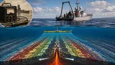
When researchers examined the readings gathered from these surveys, they noticed something unusual: bands of rock with alternating magnetic polarity, forming a striped pattern unlike anything seen on land. This pattern reflected long-term reversals in the direction of Earth’s magnetic field, preserved as new rock formed and hardened over time.More significantly, the stripes were found to be symmetrical on either side of the mid-ocean ridges, the vast underwater mountain ranges that run through the ocean basins. This symmetry supported the idea of seafloor spreading, in which new crust forms as the ocean floor pulls apart at these ridges, with magma rising to fill the gap and hardening into fresh rock aligned to the current magnetic field.
The 1966 “magic profile” provided strong evidence for seafloor spreading
The most convincing evidence emerged in 1966, when geologists presented magnetic anomaly data collected the previous year during a research voyage across the Pacific-Antarctic Ridge. The resulting profile showed such striking symmetry that it became known among scientists as the “magic profile,” and it was presented at a symposium held at the Goddard Institute for Space Studies in New York.That single set of measurements, made possible by a chain of innovations stretching back over a century and culminating in the portable fluxgate magnetometer, became one of the strongest pieces of evidence supporting seafloor spreading, and by extension, the modern theory of plate tectonics. A device once built to detect hidden submarines had, in the end, helped reveal the hidden mechanics of the planet itself.